Between the sandstone ridges of Gosford and the alluvial flats around Tuggerah, subsurface conditions across the Central Coast shift dramatically over short distances. One site might hit fresh Hawkesbury Sandstone at two metres; another, just a few hundred metres away, could be sitting on 15 metres of loose estuarine sediment. Drill rigs tell you what happens at a single point. Seismic tomography fills the gaps, giving you a continuous cross-section of seismic velocity that reveals bedrock topography, fracture zones, and material stiffness across the whole alignment. For road widening on the M1, a detention basin near Wyong, or a multi-storey structure on weathered shale, seismic refraction profiles combined with reflection processing produce the kind of ground model that geotechnical engineers actually need for design decisions rather than guesswork.
Seismic velocity is a proxy for rippability, excavatability, and rock mass modulus: it turns a geophysical measurement into a direct construction-planning input.
Technical details of the service in Central Coast NSW
Working video
Risks and considerations in Central Coast NSW
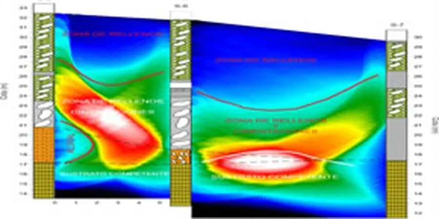
Coastal humidity and summer storms across the Central Coast create two practical headaches for seismic work: wet ground can mute high-frequency signals, and a sudden downpour near Ourimbah or Berkeley Vale can shut down a spread mid-acquisition. We schedule refraction lines early in the day during summer and use waterproofed geophone connectors as standard. A bigger risk is misinterpreting a velocity inversion, where a stiff layer overlies softer material, something that can happen in deeply weathered shale profiles where a duricrust cap masks weaker rock below. Refraction alone will miss that; that is why we run reflection or MASW on the same spread when the site stratigraphy suggests it. On slopes above the Hawkesbury River, where colluvium drapes the bedrock, we combine seismic tomography with slope stability analysis to verify that the interpreted rock surface is deep enough to anchor a retaining structure.
Our services
Our Central Coast seismic tomography service covers the full workflow from line layout to engineering interpretation. We do not just hand over a velocity image and walk away. Every project includes a report that ties seismic velocities to geotechnical parameters relevant to your excavation, foundation, or slope design.
Refraction tomography for bedrock mapping and rippability
2D P-wave velocity models for foundation design, excavation planning, and cut-fill analysis on sites from Woy Woy to The Entrance. Outputs include rippability classification, depth-to-rock contours, and material zones suitable for input into earthworks cost models.
Combined refraction-reflection profiling for deeper targets
Where the weathered zone extends beyond 20 metres or a blind layer is suspected, we run coincident reflection lines to image the fresh-rock interface. Used extensively for road tunnel feasibility studies and deep sewer alignments along the Central Coast corridor.
Top questions
What is the difference between seismic refraction and reflection, and which one do I need?
Refraction uses first-arrival travel times and works best when velocity increases with depth, making it ideal for mapping bedrock beneath soil and weathered rock. Reflection captures energy bounced back from subsurface boundaries and can image deeper layers or velocity inversions that refraction misses. For most Central Coast sites, refraction alone gives the rippability and depth-to-rock data you need. We recommend adding reflection when the weathered profile is thick, variable, or suspected to contain softer zones beneath a hard cap.
How deep can a seismic refraction line see on a typical Central Coast site?
Depth of investigation depends on spread length, not the energy source. As a rule of thumb, you can resolve layers to about 15 percent of the total geophone spread. A 120-metre spread typically images the top 15 to 20 metres with good resolution and can reach 25 to 30 metres if the velocity contrast is strong. For deeper targets we extend the spread or switch to a reflection acquisition geometry.
What kind of site access do you need for the geophones and cables?
The crew needs a reasonably clear line about one to two metres wide to lay out the geophone string. Long grass, light scrub, and gentle slopes are fine. Dense bush, steep cuttings, and hard surfaces like concrete pavement slow things down but can usually be worked around with shorter spreads or different coupling methods. If the site is heavily vegetated, let us know beforehand so we can plan the line clearing or use alternative sensor setups.
Can seismic tomography tell me whether rock can be ripped or must be blasted?
Yes, that is one of the primary outputs. Seismic P-wave velocity correlates with rock mass strength and fracturing. We apply the IAEG rippability classification, which defines velocity ranges for excavatable, marginal, and blasting conditions. Combined with local experience in Hawkesbury Sandstone and Narrabeen Group rocks, the velocity model gives a practical diggability map that earthworks contractors can use directly.
What does a seismic tomography survey cost for a residential or small commercial site on the Central Coast?
For a typical subdivision or small commercial lot requiring one or two refraction spreads, budget between AU$4,670 and AU$6,890 including mobilisation, acquisition, processing, and a concise report with depth-to-rock and rippability interpretation. Larger linear surveys or combined refraction-reflection programs are priced per lineal metre depending on spread length and access conditions.