The Central Coast corridor has transformed from quiet holiday shacks to a dense commuter belt with major infrastructure pushing into terrain that would have been bypassed a generation ago. The Gosford Formation’s interbedded sandstones and shales, overlain by highly variable Quaternary alluvium across the floodplains around Tuggerah Lake, create abrupt lateral changes in stiffness that catch out generic site classifications. Without a measured shear wave velocity profile, assumptions about Site Class can be off by an entire category—and that flows straight to the structural budget. We run MASW surveys across residential subdivisions in Wadalba through to commercial developments in Erina, delivering Vs30 values that slot directly into AS 1170.4 hazard spectra. For deeper stratigraphic control we often couple the survey with seismic refraction to resolve bedrock depth where the MASW fundamental mode loses resolution in the top 30 metres.
A site class jump from C to D under AS 1170.4 can double the seismic base shear—measuring Vs30 rather than guessing it is the cheapest insurance a project can buy.
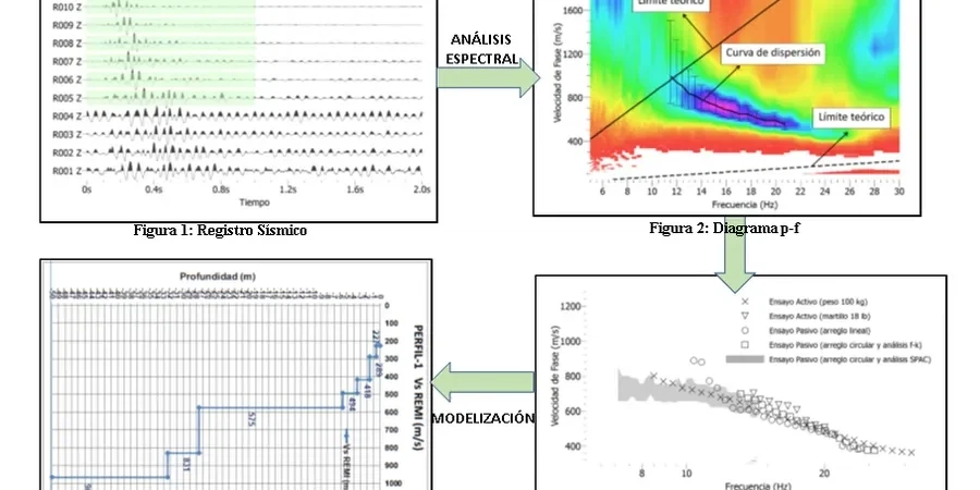
Technical details of the service in Central Coast NSW
Risks and considerations in Central Coast NSW
With the Central Coast population now exceeding 350,000 and major precincts like the Gosford waterfront and Warnervale Town Centre under active development, the exposure to seismic risk is concentrated in areas where the soil column amplifies ground motion. The 1989 Newcastle earthquake—magnitude 5.6, epicentre just 70 km north—produced Modified Mercalli intensities of VI across the Central Coast and a damage bill exceeding $4 billion in today’s dollars. Much of that damage correlated with soft soil amplification on Quaternary sediments identical to those underlying The Entrance, Long Jetty, and parts of Tuggerah. A site classified as Class C on the basis of SPT N-values alone can easily prove to be Class D or even E once the Vs30 is measured, because blow counts do not capture small-strain stiffness. Under AS 1170.4:2007 the spectral shape factor for Class D is 1.5 times that of Class C, so the structural cost penalty for a misclassification compounds across every column, shear wall, and footing on the project. The same dataset doubles as a screening tool for liquefaction susceptibility, because the Vs-based cyclic resistance ratio method is embedded in the NCEER/Youd-Idriss framework referenced by Australian practice.
Our services
Every MASW survey on the Central Coast is tailored to the site constraints and the end-use of the data—whether it is a single Vs30 figure for a DA submission or a full 1D velocity column for a dynamic soil-structure interaction model. The three packages below cover the range we deliver.
Vs30 Site Classification Package
One or two MASW arrays positioned at the building footprint, processed to a measured Vs30 value with a signed site class letter. Suitable for residential subdivisions, single commercial lots, and council DA conditions in the Central Coast LGA.
Multi-Array Zonation Survey
Five to twelve arrays on a grid across larger industrial or multi-building sites. Delivers a Vs30 contour map and site class zonation plan, allowing the structural engineer to assign different hazard spectra to different blocks.
Combined MASW + Refraction Tomography
Active MASW paired with a seismic refraction line along the same spread. The P-wave tomography resolves bedrock topography and rippability, while the MASW provides the Vs column—useful where cut-to-fill transitions cross the site.
Top questions
What does a MASW survey cost on the Central Coast, and what drives the price?
For a standard Vs30 classification using one or two active MASW arrays on an accessible Central Coast site, budget between AU$2,690 and AU$5,000. The range depends on the number of arrays, site access (slopes or dense bush around Kariong or Somersby can slow the crew), and whether passive-source recording is needed to meet the 30-metre depth requirement in softer ground. A multi-array zonation survey for a larger commercial site typically falls at the upper end or slightly above, reflecting the extra field time and the contouring deliverable.
How long does the field work take, and when do we get the report?
Field acquisition for one or two MASW arrays takes half a day on site. Processing the dispersion curves, inverting for the 1D Vs profile, and preparing the signed report is usually three to four business days. If we are combining MASW with a refraction line on the same spread, add one extra day for the tomographic inversion.
Can you do MASW inside an existing warehouse or on a concrete slab?
MASW needs geophone coupling to natural ground or compacted fill; a concrete slab scatters the surface-wave energy and produces an unusable dispersion curve. On paved sites we either work from the perimeter grassed area and model the subsurface assuming reasonable lateral continuity, or we drill through the slab and run a downhole seismic test—which is a different method but gives you the same Vs profile for site classification purposes.